Map Of Improvements
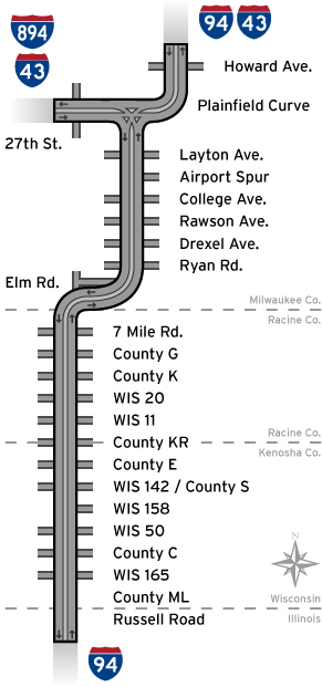
Milwaukee County
- The I-94 North-South project will update outdated designs, including the Mitchell Interchange’s mix of left and right hand entrances/exits, quick merging and weaving necessary at the 27th Street and airport exits, and scissor ramps that cross entering/exiting traffic with frontage road traffic in Racine and Kenosha counties. The reconstruction includes expanding capacity from three to four lanes in both northbound and southbound directions, providing consistent inside and outside shoulders, constructing a paved median with a concrete barrier, and pushing out frontage roads in Kenosha and Racine counties. The project includes 17 local access interchanges that will receive design improvements.
-
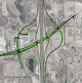
Plainfield Curve near Howard Avenue
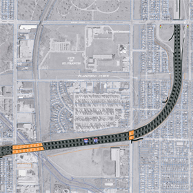
Click to view PDF (620 KB)The Plainfield Curve (I-43/94 near Howard Avenue) was reconstructed to a smoother, single curve to improve safety of traffic. This new curve is designed to accommodate speeds up to 55 mph. The Plainfield Curve was completed in Fall 2012.
-
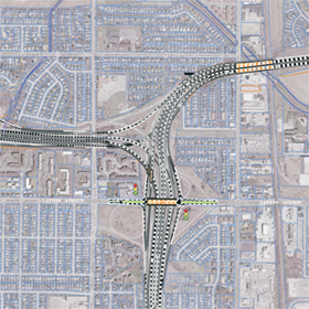
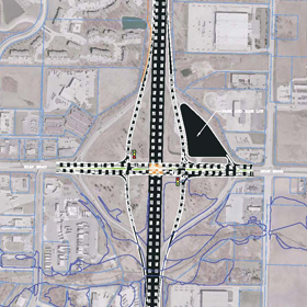
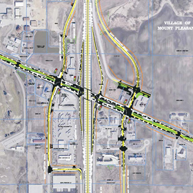
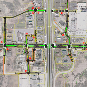
27th Street interchange
Click to view PDF (770 KB)The 27th Street Interchange was reconstructed with U-ramps to significantly improve traffic flow and safety. All traffic is now entering the freeway via right-hand turns and eliminates vehicles turning left and crossing 27th Street to access the freeway. The interchange was completed in Fall 2012.
-
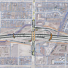
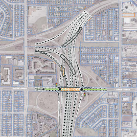
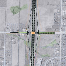
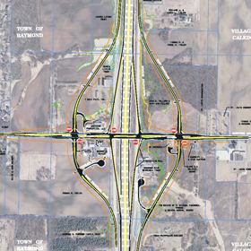
Mitchell interchange
Click to view PDF (1.6 MB)The Mitchell Interchange was reconstructed to have all traffic entering and exiting from the right. This design has eliminated confusion and improved safety. One of the more significant changes is the rerouting of maneuvers to and from 27th Street and I-94 South. Traffic on 27th Street will utilize the I-94 EAST (SB) entrance ramp from Layton Avenue to access I-94. Three tunnels were included in the design (one tunnel from I-94 WEST (NB) to I-43/894 west and two tunnels from I-43/894 east to I-43/94 north). The Mitchell Interchange was completed in Fall 2012.
-
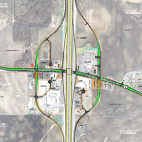
Layton Avenue interchange
Click to view PDF (853 KB)The Layton Avenue Interchange was reconstructed into a diamond configuration which will improve traffic operations on Layton Avenue. New traffic signals at the NB and SB ramp terminations were installed. The I-94 EAST (SB) entrance ramp from 20th Street was relocated to Layton Avenue. The interchange was completed in Fall 2012.
-
Airport Spur interchange
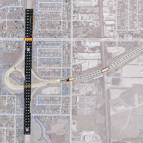
Click to view PDF (598 KB)The Airport Spur was reconstructed in its existing configuration. The newly constructed Spur looks like a parkway and has a field stone wall located in the median. The outside edges have a screening berm with landscaping. The interchange and ramps were completed in Fall 2012.
-
College Avenue interchange
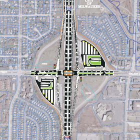
Click to view PDF (702 KB)The College Avenue Interchange was reconstructed to a tight diamond interchange. The ramp connections were brought in closer to I-94 which allows more space for the adjacent cross streets and improved traffic operations. The park and ride lots in the NE and SW quadrants were also reconstructed. The interchange was completed in 2009.
-
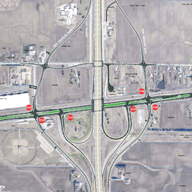
Rawson Avenue interchange
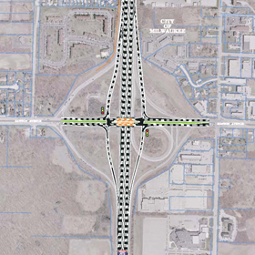
Click to view PDF (566 KB)The Rawson Avenue Interchange was reconstructed to a tight diamond interchange. The ramp connections were brought closer to I-94 which allows more space between the ramps and the adjacent cross streets – 13th Street and 20th Street, for better traffic operations. The interchange was completed in fall 2013.
-
Drexel Avenue Interchange
Click to view PDF (401 KB)The Drexel Avenue Interchange is a new interchange added to the I-94 North-South Corridor between Rawson Avenue and Ryan Road. The interchange is a tight diamond configuration where the ramps are close to I-94 for improved traffic operations. The interchange was completed in Fall 2012.
-
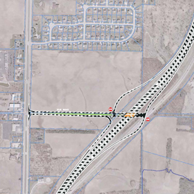
Ryan Road interchange
Click to view PDF (656 KB)The Ryan Road interchange will be reconstructed to a tight diamond interchange. This means that ramp connections with the cross street will be brought closer to I-94. Doing this allows more space between the ramp and the adjacent cross streets – 13th Street and 20th Street, for better traffic operations.
Schedule:
The Ryan Road Interchange is tentatively scheduled to be constructed in 2018.
-
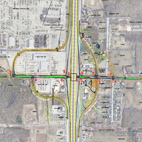
Elm Road interchange
Click to view PDF (591 KB)The existing interchange at 27th Street and I-94 will be reconstructed from a half diamond interchange to a full diamond interchange. This interchange will be moved approximately a half mile further north to avoid impacts to the Root River environmental corridor and will improve spacing with the Seven Mile Road interchange. It will be built with a connection to 27th Street.
Schedule:
The Elm Road Interchange and mainline are tentatively scheduled to be constructed in 2018.
Racine County
-
7 Mile Road interchange
Click to view PDF (1.7 MB)The existing crisscrossing ramp/frontage road configuration at 7 Mile Road will be reconstructed to eliminate the unsafe movements. The entrance/exit ramps will be configured as a diamond interchange. The east frontage road will be routed around current businesses and residences that are adjacent to the existing frontage road. The west frontage road will be routed west of 7 Mile Fair. Storm water detention ponds are planned for the NE and SE quadrants of the interchange.
Schedule:
The 7 Mile Road Interchange and mainline are tentatively scheduled to be reconstructed in 2019.
-
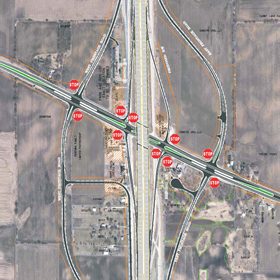
County G interchange
Click to view PDF (592 KB)The County G Interchange was reconstructed to eliminate the existing unsafe scissor ramps and reconstructed as a diamond interchange. The interchange and mainline was completed in 2009.
-
County K interchange
Click to view PDF (4 MB)The existing crisscrossing ramp/frontage road configuration at County K will be reconstructed to eliminate the unsafe movements. The entrance/exit ramps will be configured as a diamond interchange. The east and west frontage roads will be routed around current businesses and residences adjacent to the existing frontage road. Storm water detention ponds are planned for the NE, NW and SW quadrants of the interchange.
Schedule:
The County K Interchange and mainline are tentatively scheduled to be reconstructed in 2021.
-
WIS 20 interchange
Click to view PDF (565 KB)The WIS 20 Interchange was reconstructed to a tight diamond interchange which eliminated the unsafe movements from the previously existing criss-crossing ramp/frontage road configuration at the interchange. The County C bridge over I-94 was also reconstructed as part of this project. The interchange was completed in Fall 2015.
-
WIS 11 interchange
Click to view PDF (792 KB)The entrance/exit ramps will be constructed with a partial cloverleaf configuration, similar to the existing configuration. The east frontage road will be realigned east of its current configuration north of Old Hwy 11 and the west frontage road will be realigned west of its current configuration north of 58th Road. 58th Road between the frontage roads will also be improved as part of this project.
Schedule:
The WIS 11 Interchange and mainline are tentatively scheduled to be reconstructed in 2020.
Kenosha County
-
County KR interchange
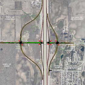
Click to view PDF (1.4 MB)The existing crisscrossing ramp/frontage road configuration at County KR will be reconstructed to eliminate those unsafe movements. The entrance/exit ramps will be configured as a diamond interchange. The east and west frontage roads will be routed around current business and residences adjacent to the existing frontage road. The stream along County KR, east of I-94, will be realigned. A storm water detention pond is planned for the SE quadrant of the interchange.
Schedule:
The County KR Interchange and mainline are tentatively scheduled to be reconstructed in 2020.
-
County E interchange
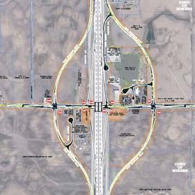
Click to view PDF (550 KB)The existing crisscrossing ramp/frontage road configuration at County E will be reconstructed to eliminate those unsafe movements. The entrance/exit ramps will be configured as a diamond interchange. The east and west frontage roads will be routed around current business and residences adjacent to the existing frontage road. Storm water detention ponds are planned for the NE, NW and SE quadrants of the interchange.
Schedule:
The County E Interchange and mainline are tentatively scheduled to be reconstructed in 2020.
-
WIS 142/County S
Click to view PDF (1 MB)The WIS 142/County S Interchange was reconstructed to a tight diamond interchange which eliminated the unsafe movements from the previously existing criss-crossing ramp/frontage road configuration at the interchange. The interchange was completed in Fall 2014.
-
WIS 158 interchange
Click to view PDF (1 MB)The WIS 158 Interchange was reconstructed to a tight diamond interchange which eliminated the unsafe movements from the previously existing criss-crossing ramp/frontage road configuration at the interchange. The interchange was completed in fall 2013
-
WIS 50 interchange
Click to view PDF (2.2 MB)WIS 50 Interchange: The WIS 50 Interchange was reconstructed to a diamond interchange with new connecting ramps to/from 71st st on the north side. The interchange was completed in fall 2013.
WIS 50 Local Roads: WIS 50 between 130th St and 104th St is scheduled to be reconstructed to a 3-lanes in each direction roadway. The project began construction in spring 2013 and is scheduled to be completed in fall 2014.
-
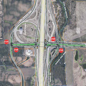
County C interchange
Click to view PDF (3.1 MB)The County C Interchange was reconstructed to eliminate the existing unsafe scissor ramps as a tight diamond configuration. The interchange was completed in 2009.
-
WIS 165 interchange
No changes to the existing interchange configuration are planned
-
County ML interchange
No changes to the existing interchange configuration are planned.
-
Russell Road Interchange by IDOT (Illinois)
The Russell Road interchange will be reconstructed in its current configuration.